 New Bedford Guide Your Guide to New Bedford and South Coast, MA


So what we have here is a hill where a cooking stove for tar is, right? Well, sure. In lay terms that is exactly what we have here, but this “tar kiln” refers to something very specific.
Most people think of paved roads or streets when they hear the word “tar,” but from the Iron Age onward much of the world has been using tar for a multitude of reasons. Europeans turned it into an industry and commodity and of course American colonists were quick to utilize it. Tar was used for preserving and water-sealing/repellent on wooden sailing vessels, leather clothing, sails and roofs. It kept out the ocean water, rain or rot.
Unknown to many is that it was also used as a general disinfectant, to flavor candies or amazingly as a panacea or medicine for those mortally wounded. Today it is still used in dandruff shampoos, in cosmetics, paint and of course, preserving wood surfaces.

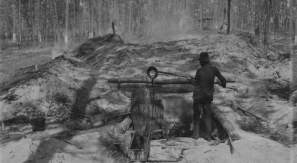
Where does the kiln come in? Tar is a product of burning wood – primarily pine, hence the term pitch pine or candlewood – for hours or even days in a closed environment. The fire would burn far past the point that the wood became charcoal. You need a kiln for that – often made from limestone and where that wasn’t available a deep pit was dug. There was a slight gradient to the kiln, so that the liquid tar could ooze out and be collected.

An integral aspect to the process is the minimizing of oxygen, but maintenance of the heat. This is achieved by covering the charcoal in moss and/or dirt. For days the tar would be collected. If you are a history buff or farmer, you know that nothing was ever wasted in colonial times. Once all the tar was extracted, the dirt and moss would be swept aside and the charcoal and by-product of tar kilns – turpentine and pitch – would be also collected.
Tar, pitch, turpentine and charcoal all became commodities to export back “home” in England. Since the colonists were perpetually clearing forests to build towns, homesteads and farmsteads these commodities were in abundance. In fact, it become an industry that burgeoned so much that towns began to complain about the odor and constant smoke from the glut of tar kilns. Some states like New Hampshire even allowed residents to pay in tar instead of currency. In the 17th century Massachusetts tried to stem the destructive industry by putting caps on the amount of barrels that could be produced annually.
Eventually lumber and ice harvesting come onto the scene and many jumped ship, pardon the pun. However, it did undergo a short lived revival in the early part of the 20th century.
So we’ve clarified what a tar kiln was and how our forebears in the region utilized it in a typically New England industrious way. So why in tarnation – again, pardon the pun – was this road specifically called Tarkiln Hill Road? This stretch of road is Main Street in Acushnet, becomes Tarkiln Hill Road once you cross “the river” and turns into King’s Highway once it hits Route 18. Coincidentally, nearby Pine Grove Cemetery was originally known as Tarkiln Hill Burial Ground prior to 1853 – before the city owned it.


So why does the street signs along the length of road have different spellings. Next time you travel the road look at the signs there spelling is different.
Hi Mike – I touch upon this briefly in the article.
Both spellings are correct. You can separate “tar” and “kiln” or compound them. The term is outdated, archaic and infrequently used so a search on Merriam-Webster Dictionary, Dictionary.com, and the Cambridge Dictionary turned up no entries for “tar kiln” or “tarkiln.”
Common usage seems to be that when separated they refer to the actual kiln itself, and when compounded it refers to a street. There are three other Tarkiln Roads in America and all are compounded. Historical documents refer to the kilns themselves as “tar kiln.” I chose to use this method within this article, but it doesn’t seem there are hard and fast rules.
I’m not sure if this is what Mike Charles was referring to, but…. quite some time back, I noticed one street sign where it was spelled TarKLin ( K & L reversed). Some months after I noticed it had been changed to the correct spelling. ( Tarkiln)
Many locals DO pronounce the ending as “KLIN” though.
My bad… I said the K and L were reversed, when I should have said misplaced.
You are correct. I’ve heard that countless times over the years. It highlights how words evolve over the years and how American English has changed from the Queen’s that was spoken among settlers and colonists.
It also highlights how rarely we use kiln in everyday speech, something I also touched upon in the article. Many people don’t know what a kiln is, so if someone says klin, there is no feedback correcting it.
Thanks for sharing!
Thank you for this article. So it seems my mother was correct..
Mike said exactly what I was going to say. I forgot which sign(s) were wrong but I definitely saw at least one that said “Tarklin Hill Road”. Spelled exactly as some people mispronounce it. The others say “Tarkin Hill Road”. I noticed the misspelled sign a while ago. I just now took a trip up “The Hill” via Google Maps. All the signs appear to be correct. Also Ian is correct (below) Tarkiln Hill Road used to go straight through to where Mount Pleasant and New Plainville Road meet. This is one of the many Army tank sits. I remember my friends and I riding our bikes to the tank (we used to be able to crawl under the tank, open the hatch and climb inside). This was before Route 140 was built. Before Route 140 was built, Church Street to Braley Road (another road cut in two by Rt 140) was the route to take if we were heading north. My parents grew up on “The Hill” married and raised us there. My 94 year old father still lives on Church Street where he’s been for 65+ years. I will ask him for any info he may remember.
I love reading these stories…awesome. Keep it up!
Great article. Just a slight correction, it remains Tar Kiln Hill Rd. past Rt. 18 all the way up to the Wendy’s in front of S&S, where it bears to the right and goes behind the Stop & Shop. Then it gets cut off by 140, and the other end of it can be found on the other side of 140, off Mt. Pleasant St.
Thanks for the correction Ian. Much appreciated!
Joe, Have been reading the New Bedford Guide. You are doing a thorough job. Have been wondering where the tar kilns were on this road for years. Do you know about the pond that existed between Pine Grove Cemetery east to Caswell street?
Keep up the good work.
Thanks a bunch Jeanne. Means a lot.
Ironically I was talking to another reader through email and he mentioned this pond – the first I’ve heard of it. He mentioned that the brook and pond got covered in the 1920s.
I made an effort to locate the tar kilns, but I couldn’t pinpoint them. There is little to nothing about them. Their temporary nature means that out of practicality they were shifted as trees were harvested so the distance from harvest to production was short as possible.
Also, since the height of production was from the late 17th century into the 18th century before the industry faded and was replaced, the sheer age means there aren’t many historic documents about them.
Hello Mrs. Swiszcz. You were one of my Girl Scout Leaders.
I grew up in that area when it was woodlands..the area was known as ” Five (5) Alleys” and the pond was Hawes Pond, named after the owners of the Acushnet Saw Mill which was located on River Road. Water running into Hawes Pond first entered into the pond that is located in Pine Grove Cemetery. Those ponds are now void of water due to the construction of homes and development ( especially NB Regional Vocational High School)l.
Joe,
I’ve always wondered who Topham Street was named after. My great grandmother’s maiden name is Topham and her family had a Lumber Company during the whaling days in the 1800’s and one of her Uncles was the City Assessor.
Maybe you could add this street to your list – please?
Thanks for all you do…..great article on Kinyon-Campbell too – my Dad, Gerald Sherman, was a teacher and Dean there for years and absolutely loved the school. His students were his friends and enjoyed going to work everyday!
Hi C.P.,
Thanks for the kind words. The Sherman name is a storied one in New Bedford’s history and there are quite a few documents detailing it.
I just opened a draft for Topham Street and will do it this weekend. I’m looking forward to it.
Wow, great work that you are doing here. Please keep it going. So informative and a great read always, thanks so much..