 New Bedford Guide Your Guide to New Bedford and South Coast, MA

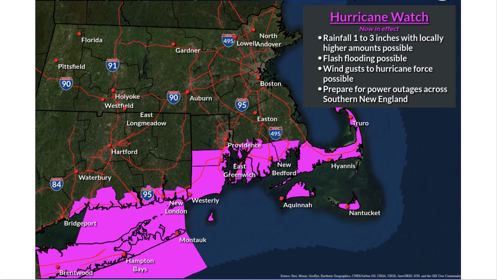


A Hurricane Watch means hurricane-force winds are possible somewhere within this area within the next 48 hours
A Storm Surge Watch means life-threatening inundation, from rising water moving inland from the coastline, is possible somewhere within this area within the next 48 hours.
* LOCATIONS AFFECTED
– Fall River
– New Bedford
* WIND
– LATEST LOCAL FORECAST: Equivalent Strong Tropical Storm force wind
– Peak Wind Forecast: 45-60 mph with gusts to 80 mph
– Window for Tropical Storm force winds: Saturday evening until Monday morning
– THREAT TO LIFE AND PROPERTY THAT INCLUDES TYPICAL FORECAST UNCERTAINTY IN TRACK, SIZE AND INTENSITY: Potential for wind 58 to 73 mph
– PLAN: Plan for dangerous wind of equivalent strong tropical storm force.
– PREPARE: Efforts to protect life and property should now be underway. Prepare for significant wind damage.
– ACT: Act now to complete preparations before the wind becomes hazardous.
– POTENTIAL IMPACTS: Significant
– Some damage to roofing and siding materials, along with damage to porches, awnings, carports, and sheds. A few buildings experiencing window, door, and garage door failures. Mobile homes damaged, especially if unanchored. Unsecured lightweight objects become dangerous projectiles.
– Several large trees snapped or uprooted, but with greater numbers in places where trees are shallow rooted. Several fences and roadway signs blown over.
– Some roads impassable from large debris, and more within urban or heavily wooded places. A few bridges, causeways, and access routes impassable.
– Scattered power and communications outages, but more prevalent in areas with above ground lines.

* STORM SURGE
– LATEST LOCAL FORECAST: Life-threatening storm surge possible
– Peak Storm Surge Inundation: The potential for 2-4 feet above ground somewhere within surge prone areas
– Window of concern: Around high tide
– THREAT TO LIFE AND PROPERTY THAT INCLUDES TYPICAL FORECASTUNCERTAINTY IN TRACK, SIZE AND INTENSITY: Potential for storm surge flooding greater than 3 feet above ground
– PLAN: Plan for life-threatening storm surge flooding of greater than 3 feet above ground.
– PREPARE: Storm surge flooding preparations should be underway. Assemble disaster supplies and know your evacuation route.
– ACT: Leave if evacuation orders are given for your area. Failure to heed evacuation orders may result in the loss of your life.

– POTENTIAL IMPACTS: Significant
– Areas of inundation with storm surge flooding accentuated by waves. Damage to several buildings, mainly near the coast.
– Sections of near-shore escape routes and secondary roads become weakened or washed out, especially in usually vulnerable low spots.
– Major beach erosion with heavy surf breaching dunes. Strong and numerous rip currents.
– Moderate damage to marinas, docks, boardwalks, and piers. Several small craft broken away from moorings, especially in unprotected anchorages.
* FLOODING RAIN
– LATEST LOCAL FORECAST:
– Peak Rainfall Amounts: 2-4 inches, with locally higher amounts
– THREAT TO LIFE AND PROPERTY THAT INCLUDES TYPICAL FORECASTUNCERTAINTY IN TRACK, SIZE AND INTENSITY: Potential for moderate flooding rain
– PLAN: Emergency plans should include the potential for moderate flooding from heavy rain. Evacuations and rescues are possible.
– PREPARE: Consider protective actions if you are in an area vulnerable to flooding.
– ACT: Heed any flood watches and warnings. Failure to take action may result in serious injury or loss of life.
– POTENTIAL IMPACTS: Significant
– Moderate rainfall flooding may prompt several evacuations
and rescues.
– Rivers and tributaries may quickly become swollen with swifter currents and overspill their banks in a few places, especially in usually vulnerable spots. Small streams,
creeks, and ditches overflow.
– Flood waters can enter some structures or weaken foundations. Several places may experience expanded areas of rapid inundation at underpasses, low-lying spots, and poor drainage areas. Some streets and parking lots take on moving water as storm drains and retention ponds overflow. Driving conditions become hazardous. Some road and bridge closures.
* TORNADO
– LATEST LOCAL FORECAST:
– Situation is unfavorable for tornadoes
– THREAT TO LIFE AND PROPERTY THAT INCLUDES TYPICAL FORECASTUNCERTAINTY IN TRACK, SIZE AND INTENSITY: Tornadoes not expected
– PLAN: Tornadoes are not expected. Showers and thunderstorms with gusty winds may still occur.
– PREPARE: Little to no preparations needed to protect against tornadoes at this time. Keep informed of the latest tornado situation.
– ACT: Listen for changes in the forecast.
– POTENTIAL IMPACTS: Little to None
– Little to no potential impacts from tornadoes.
* FOR MORE INFORMATION:
– https://www.weather.gov/box


