 New Bedford Guide Your Guide to New Bedford and South Coast, MA


The National Weather Service has issued a Winter storm watch effective from late Wednesday night through late Thursday night. Total snow accumulations of 8 to 12 inches.
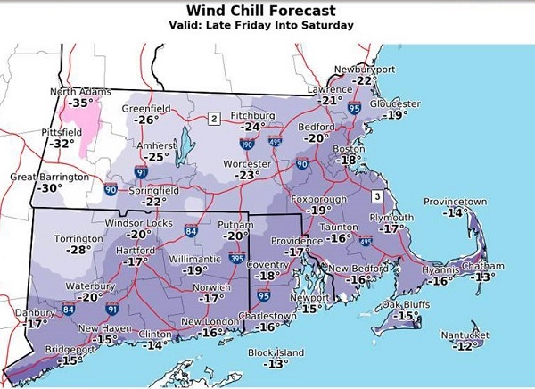
Damaging wind gusts and power outage risk a big concern across eastern MA/RI given bitterly cold wind chills of 15 to 35 below zero to follow later Friday into Saturday.
* WHAT…Heavy snow possible. Plan on difficult travel conditions. Damage to trees and power lines is possible. Total snow accumulations of 8 to 12 inches
* WHERE…Portions of eastern, northeastern and southeastern Massachusetts and northern and southern Rhode Island, Including the cities of Gloucester, Foxborough, Norwood, Cambridge, Boston, Quincy, Taunton, Brockton, Fall River, New Bedford, Mattapoisett, Foster, Smithfield, Providence, Coventry, West Greenwich, East Greenwich, Warwick, West Warwick, Bristol, Narragansett, Westerly, Newport, and New Shoreham.

* WHEN…From late Wednesday night through late Thursday night.
* ADDITIONAL DETAILS…Significant reductions in visibility are possible including near blizzard conditions for a time Thursday.
PRECAUTIONARY/PREPAREDNESS ACTIONS
A Winter Storm Watch means there is potential for significant snow, sleet or ice accumulations that may impact travel. Continue to monitor the latest forecasts.


