 New Bedford Guide Your Guide to New Bedford and South Coast, MA

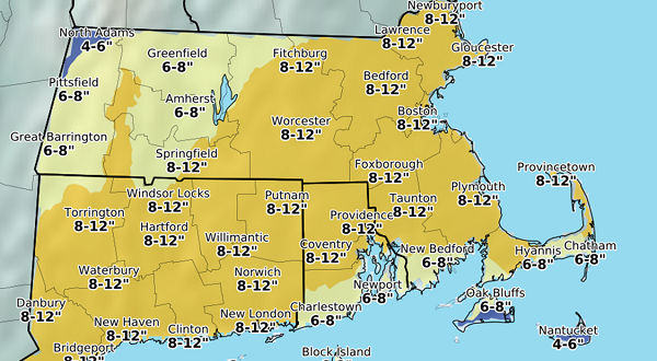


Here are the updated snowfall totals predicted for Thursday.
URGENT – WINTER WEATHER MESSAGE – National Weather Service Taunton MA
251 PM EST Tue Feb 7 2017
Western Norfolk MA-Suffolk MA-Eastern Norfolk MA-Northern Bristol MA-Western Plymouth MA-Eastern Plymouth MA-Southern Bristol MA-Southern Plymouth MA-Barnstable MA-Dukes MA-
Southeast Providence RI-Western Kent RI-Eastern Kent RI-Bristol RI-Washington RI-Newport RI-Block Island RI-Including the cities of Foxborough, Norwood, Boston, Quincy,Taunton, Brockton, Plymouth, Fall River, New Bedford,Mattapoisett, Chatham, Falmouth, Provincetown, Vineyard Haven,
Providence, Coventry, West Greenwich, EAST GREENWICH, WARWICK, WEST WARWICK, Bristol, Narragansett, Westerly, Newport, and BLOCK ISLAND
WINTER STORM WATCH IN EFFECT FROM WEDNESDAY EVENING THROUGH LATE THURSDAY NIGHT
The National Weather Service in Taunton has issued a Winter Storm Watch which is in effect from Wednesday evening through late Thursday night.
* LOCATIONS…Eastern Massachusetts and Rhode Island.
* HAZARD TYPES…Heavy snow.

* Accumulations…Snow accumulation of 8 to 12 inches.
* TIMING…Snow will begin early Thursday morning and last through much of the day before ending Thursday evening. Snow could fall heavy at times and impact both the morning and evening commutes.
* IMPACTS…Hazardous travel due to snow covered roads and poor visibilities. Blowing and drifting snow is possible.
* Winds…North 20 to 30 mph with gusts up to 45 mph.
PRECAUTIONARY/PREPAREDNESS ACTIONS…
A Winter Storm Watch means there is a potential for significant snow…sleet…or ice accumulations that may impact travel. Continue to monitor the latest forecasts. Be prepared to modify
travel plans should winter weather develop.


