 New Bedford Guide Your Guide to New Bedford and South Coast, MA


A WINTER WEATHER ADVISORY will go into effect at 4pm Today till 7pm Sunday January 20th
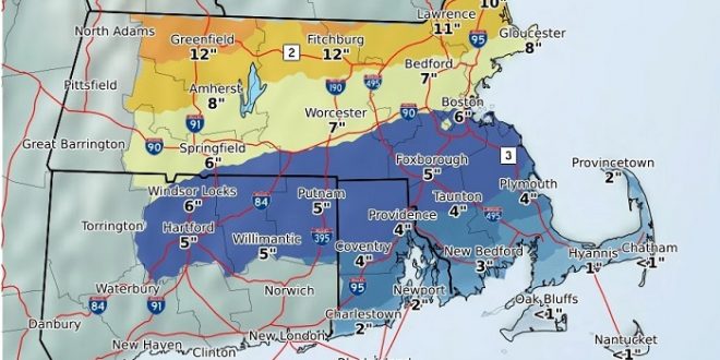
* WHAT…Mixed precipitation expected. Total snow accumulations of 1 to 3 inches and ice accumulations of up to one tenth of an inch expected. Winds gusting as high as 40 mph.
* WHERE…In Massachusetts, Southern Bristol and Southern Plymouth Counties. In Rhode Island, Bristol, Washington and Newport Counties.
* WHEN…Mainly this evening through Sunday afternoon.
* ADDITIONAL DETAILS…Plan on slippery road conditions.
Temperatures plunging into the mid 20s by early Sunday evening will result in a flash freeze and wet roads becoming icy. Any mixed precipitation will end as a period of snow Sunday afternoon. Travel may be very difficult at times tonight, and again Sunday afternoon and evening.
PRECAUTIONARY/PREPAREDNESS ACTIONS.
A Winter Weather Advisory means that periods of snow, sleet or freezing rain will cause travel difficulties. Expect slippery
roads and limited visibilities, and use caution while driving.
___________________________________________________________________________________
A COASTAL FLOOD ADVISOR will go into effect at 5am to 10am Sunday January 20th….
* LOCATIONS…In Massachusetts, Southern Bristol MA and Southern Plymouth MA. In Rhode Island, Washington RI, Bristol RI, Eastern Kent RI and Newport RI.
* TIMING…From 5 AM to 10 AM EST Sunday.
* COASTAL FLOOD IMPACTS…Flooding of the most vulnerable shore roads is expected. The majority of roads remain passable with only isolated closures around high tide. Inundation of up to one foot above ground level.

PRECAUTIONARY/PREPAREDNESS ACTIONS…
A Coastal Flood Advisory is issued for minor coastal flooding of the most vulnerable shore roads and/or basements due to the height of storm tide or wave splashover. The majority of roads remain passable with only isolated closures. There is no significant threat to life…and impact on property is minimal.
DETAILED FORECAST…
Today
A slight chance of snow after 11am. Increasing clouds, with a high near 34. North wind 6 to 8 mph becoming east in the afternoon. Chance of precipitation is 20%.
Tonight
Snow before 1am, then rain and snow between 1am and 3am, then rain after 3am. The rain could be heavy at times. Low around 30. East wind 8 to 17 mph, with gusts as high as 36 mph. Chance of precipitation is 100%. New snow accumulation of 1 to 3 inches possible.
Sunday
Rain before 3pm, then freezing rain likely between 3pm and 4pm, then a chance of freezing rain and sleet after 4pm. The rain could be heavy at times. Temperature rising to near 38 by 9am, then falling to around 26 during the remainder of the day. Southeast wind 13 to 15 mph becoming northwest in the afternoon. Winds could gust as high as 39 mph. Chance of precipitation is 100%. Little or no sleet accumulation expected.
Sunday Night
A chance of snow showers and sleet before 7pm, then a slight chance of snow showers between 7pm and 11pm. Cloudy, then gradually becoming partly cloudy, with a low around 8. Wind chill values as low as -7. Northwest wind 15 to 17 mph, with gusts as high as 41 mph. Chance of precipitation is 30%. New snow and sleet accumulation of less than a half inch possible.