 New Bedford Guide Your Guide to New Bedford and South Coast, MA


A powerful low-pressure system currently being tracked is taking shape along the central Gulf coast as it rapidly intensifies and gains strength. Tonight it is forecasted to turn north-northeast and creep up the Eastern Seaboard on its way to Massachusetts, arriving early Saturday morning.
The storm is expected to be upgraded to a “bomb cyclone” which is when the atmospheric pressure at the center of the storm plummets by 0.71 of an inch of mercury within a 24 hour period. This storm is expected to exceed that criterion by a large margin.

Accuweather photo.
West and north of Boston will see significant snow, even blizzard-like conditions and white-outs, as the snow falls at the rate of 1-3 inches per hour; great news for skiers and snowboarders. Instead of shovable and plowable snow, those of us east and south of the weather line will receive significant rainfall, enough to cause street and highway flooding. At times the downpours will drop the visibility to near zero, worsening the already incredibly hazardous travel conditions.
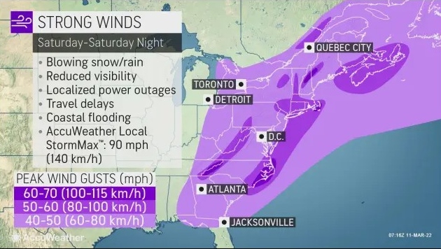
As the storm strengthens on Saturday afternoon wind gusts will reach up to 60-70mph knocking down trees and powerlines causing loss of power, send flying anything not tied down, and placing obstacles in the road.
As the storm leaves the area on Sunday we’ll be left with gusty winds and temperatures in the 20s, meaning the road conditions will still be hazardous with many patches of black ice.
Accuweather photo.