 New Bedford Guide Your Guide to New Bedford and South Coast, MA
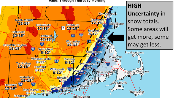


The US National Weather Service in Boston has increased their snowfall totals slightly higher along the Boston to Providence corridor, but there is still high uncertainty in these areas.
Most of the accumulation will take place between 6 PM-Midnight. For Boston, expect around 2″ in the city & 4-6″ in the western suburbs. Meanwhile, The US National Weather has a HIGH confidence in snowfall totals for Connecticut, western and central Massachusetts, and northwest Rhode Island.
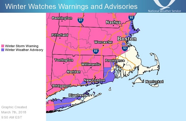
The Flood Watch continues for portions of southeastern Massachusetts and Rhode Island, including the following areas, in southeastern Massachusetts, Bristol, and Plymouth. In Rhode Island, Bristol, Eastern Kent, Newport, and Washington through Thursday afternoon.
Steady rain will begin this afternoon and will be heavy at times through this evening. While the rain may change to a period of snow, most of what falls should be rain.

A quick 1 to 2 inches of rain may result in some renewed river and stream flooding. There may also be some urban and poor drainage street flooding issues given the heaviest rain will coincide with the evening rush hour.
PRECAUTIONARY/PREPAREDNESS ACTIONS
A Flood Watch means there is a potential for flooding based on current forecasts.
You should monitor later forecasts and be alert for possible Flood Warnings. Those living in areas prone to flooding should be prepared to take action should flooding develop.